Although we are very dependent on abundant clean water, we only test the quality of our water in a relatively few places and few times. Mostly, we rely on local and national government agencies (e.g., water treatment facilities, EPA). Hach of Boulder Colorado realized that if testing were easier and could be done in less time, more tests would be taken. That's why Hach's new water tester is a big win for clean water.
Take a look at Hach's video portraying the old (30 minutes) and new (8 minutes) way to test water.
Sometime in the near future, citizen scientists will be able to take high-quality measurements of nearby water sources and provide this data to a global database. We will know quickly where the hot spots are and be able to take action before pollution is out of control.
Wednesday, August 27, 2014
Tuesday, August 12, 2014
It's not just Lake Erie that's dying.
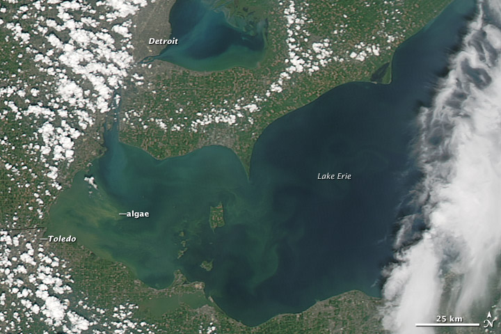 |
| Image from NOAA, August 3, 2014 |
What's being done to protect Lake Erie from Phosphorus runoff? Nothing official although some individual farmers set aside about 3% of their land to create a runoff buffer. The rights of the millions who drink Lake Erie water are pitted against the rights of landowners to do what they wish. Actually, what most farmer's wish is that the nutrients would stay on their land and not run off, but preventing runoff has different solutions and different properties and always involves costs. The consequence of this laissez faire policy is a nearly dead Lake Erie along with hundreds of smaller lakes throughout the Country.
In the 1970s detergent manufacturers were compelled to remove phosphorus from their products, which over a decade brought Lake Erie back to health. Since then, however, the runoff from unregulated farms has driven the lake back to the brink.
 |
| Jeff Reutter, Ohio Sea Grant and Stone Laboratory |
"Flooded by tides of phosphorus washed from fertilized farms, cattle feedlots and leaky septic systems, the most intensely developed of the Great Lakes is increasingly being choked each summer by thick mats of algae, much of it poisonous." For more information read Behind Toledo's Water Crisis.
Ohio Sea Grant recommends that each contributor reduce their phosphorus output by 40%. This would have a similar effect to that of removing phosphorus from detergent and bring Lake Erie back to life and protect drinking water and the lake's ecosystem.
Pollution concerns persist about tides of phosphorus in the Great Lakes and in waterways across the United States.
Tuesday, August 5, 2014
Port Washington Power
 |
| Port Washington Light (right-center) and Generating Station (far left). |

Initially constructed during the depression (1930-1935) to supply power to the growing needs of Milwaukee. It burned pulverized coal until 2000 when it was shut and converted to natural gas. Two turbines are online (2003 and 2005). These turbines produces as much CO2 each day as 50-thousand people.
Monday, August 4, 2014
The Long Curve
We usually think of going from point A to point B in a Cartesian manner: a straight line. Sailboats are not so linear even with all of their electronic navigation gear. As Beth and I set out for Washington Island, WI from Beaver Island, MI we'd hoped for a Southeast wind and a beam reach. What we got was wind that was slightly west of south, which put Speakeasy on a very close haul, which it does poorly and with our regret due to the uncomfortable ride.
I determined from a wind map based on NOAA data that the wind would become more southerly as the day wore on so after a conference with the sleepy crew, we decided to set the auto helm to 30 degrees apparent and let the boat follow the changing wind. When locked into the wind rather than a compass point, the auto helm keeps the boat pointed toward a particular angle to the wind direction. If the wind did not change for the better, we would end up on the shore of the Garden Peninsula rather than Rock Island and Washington Island, which are south of it.
Fortunately, NOAA had predicted the wind shift accurately and our track followed this bow curve toward our intended destination. In the following image, the blue triangle represents Speakeasy current location and direction. The grey dashed lines behind the triangle represent the actual locations in the past. Notice that this dashed line has curved toward the southwest as NOAA predicted.

Subscribe to:
Posts (Atom)
